
Scientific program
- Overview
- Online Program
- Panel Discussion
- Short Abstract Volume
- Key Topics
- Contributed Sessions
- Methods
- Areas of Applications
Overview
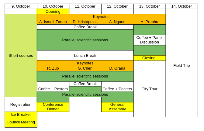
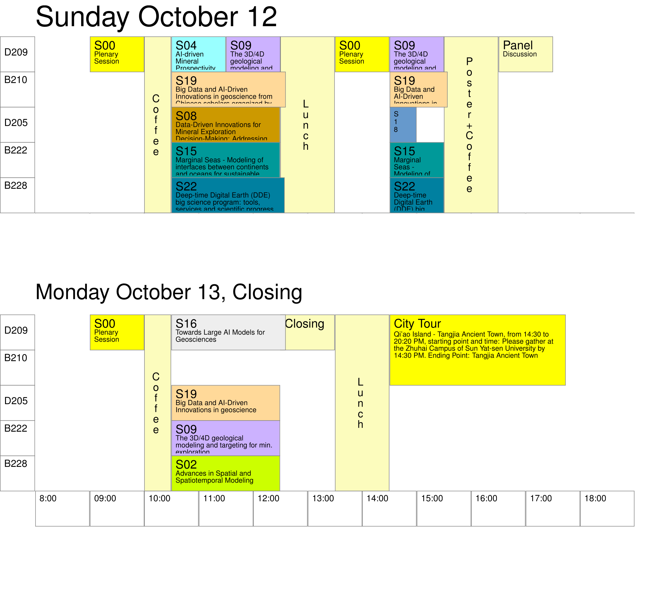
Panel Discussion
Theme: How to couple AI with Earth System Science in support of SDGsTime and place: October 12 (16:30–17:30 PM, Meeting Room D209, Haiqing 4, Zhuhai)
Panelists: Prof. Alik Ismail-Zadeh; Prof. John Carranza; Prof. Jennifer McKinley; Prof. Qiuming Cheng
Chair: Dr. Ute Müller
Short Abstract Volume
Can be downloaded here.
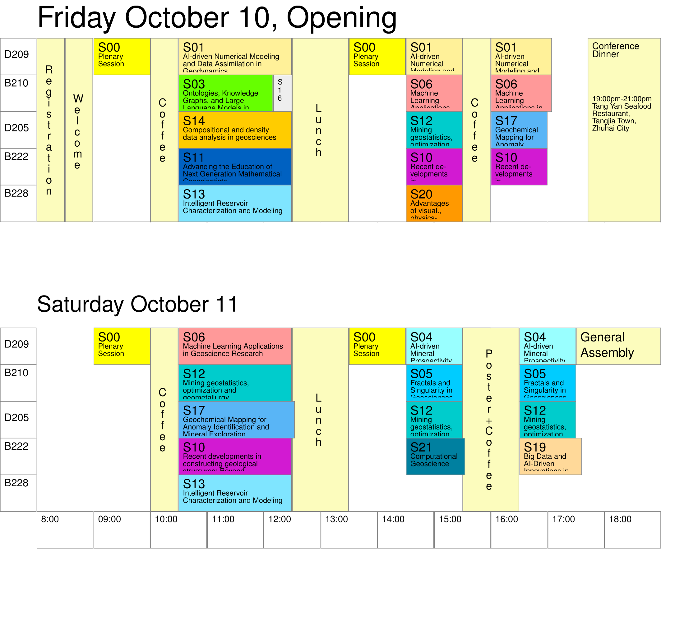
Contributed Sessions
The selection of a session is optional.
Click on the titles marked  to see a description.
to see a description. - AI-driven Numerical Modeling and Data Assimilation in Geodynamics
Fan Xiao, Dunhui Xiao, Zenghua Li, Xiaohui Li, Zhankun Liu, Xinguang HeThe numerical modeling of geodynamics such as mineralization, diagenesis, and tectonic processes is based on the fundamental principles of mathematics, physics, and chemistry. Integrating geological data allows us to construct robust mathematical-physical models for quantitatively characterizing these geological processes. These models can be solved to simulate the complex geosystems and their spatiotemporal responses under extreme conditions within the inner Earth using numerical analysis methods such as finite element or finite difference and high-performance computing. This approach aims to investigate the mechanisms inherited in complex geological processes, and their evolutionary pathways, and to interpret the conditions of geological events. Nevertheless, geodynamics, including mineralization, diagenesis, and tectonic modeling, possess strong uncertainties due to dependence on unknown or ambiguous boundary conditions, initial conditions, and physical-chemical parameters. This requires the assimilation of observational data into physical-informed numerical models to improve the accuracy of solutions or predictions. In recent years, driven by the analytics of big data, computational science, and non-linear theories and methods in complex physical systems, significant progress has been made in the numerical modeling of geodynamics. Invited submissions for abstracts or/and full papers include (but are not limited to): (1) Numerical simulation of geological processes such as mineralization, diagenesis and tectonics; (2) Computational geochemistry; (3) Computational geophysics; (4) Numerical geotectonic and geodynamic modeling; (5) Data-driven numerical modeling approach; (6) High-performance and high-throughput computing for geoscience data; (7) Data assimilation techniques in geosciences; (8) Data-driven modeling and state estimation of Earth's dynamic systems. The full papers can be recommended to be published in the IAMG journal of Computers & Geosciences or Applied Computing and Geosciences.
- Advances in Spatial and Spatiotemporal Modeling
Dionysios Christopoulos, Yongze SongThis session invites researchers to present the latest studies in spatial association methods and their practical applications. Accurate characterization of spatial association is fundamental for exploring spatial factors, improving spatial predictions, and supporting informed geographical decision-making. Models addressing spatial dependence, heterogeneity, geocomplexity, singularity, and similarity are central to describing spatial association. Moreover, recent developments in geospatial artificial intelligence have introduced powerful and precise approaches for analyzing spatial association. We welcome submissions from both theoretical and applied studies that contribute to the advancement of spatial association analysis. The development of space-time methods remains at the forefront of current research in Spatial Statistics and Machine Learning. Flexible and interpretable models that can accurately capture the complex patterns of dynamic processes and reliably estimate uncertainties are needed. The key modeling challenges for the analysis of modern spatiotemporal data include the development of models that scale favorable with large data size, ability to handle heterogeneous data, multivariate dependence, multiple correlation scales, and the development of practical non-Gaussian probability distribution and non-stationarity. This session aims to assemble contributions that will advance spatiotemporal methods in mathematical geosciences by introducing novel concepts and methodologies, computational algorithms, and innovative applications or studies that focus on interesting or challenging spatiotemporal datasets. Topics of interest include the development of novel space-time covariance functions (e.g., non-separable models, models on the sphere and manifolds, multivariate dependence, complex-valued models), covariance-free approaches (e.g., models based on stochastic partial differential equations and explicit precision operators), innovative simulation methods, and computational advances for big space-time datasets. The session also invites contributions that focus on causal inference, uncertainty quantification, applications of deep learning to spatiotemporal datasets, non-Gaussian space-time approaches and multiscale models. Interdisciplinary contributions that combine the spatiotemporal dimension with physics, machine learning, and applied mathematics perspectives are also welcome.
- Ontologies, Knowledge Graphs, and Large Language Models in Geoscience: Construction and Application
Xiaogang Ma, Chengbin Wang, Anirudh PrabhuAs the geoscience community increasingly turns to advanced AI methods, the integration of ontologies, knowledge graphs, and large language models (LLMs) offers transformative potential for data management and knowledge discovery. This session aims to explore innovative approaches to constructing and applying these technologies within geoscience. We invite presentations that demonstrate the development of ontologies and knowledge graphs specific to geoscientific domains, showcasing how these models and frameworks can enhance data interoperability and semantic clarity. In particular, we welcome presentations that demonstrate how the machine-readable semantics are leveraged in reasoning and inference tasks that lead to new knowledge discoveries. Moreover, we encourage discussions on the utilization of LLMs for data science tasks in geoscience, such as automation of literature review, hypothesis generation, and enhanced data querying and analysis. Other presentations such as using knowledge graph to guide and advise LLMs in data-intensive research are also encouraged. By bringing together experts in geoinformatics, artificial intelligence, and mathematical geosciences, this session aims to stimulate interdisciplinary dialogue and identify best practices for leveraging these advanced tools. Join us in exploring and discussion how the synergistic application of ontologies, knowledge graphs, and LLMs can advance a variety of topics in geoscience.
- AI-driven Mineral Prospectivity Modeling
Emmanuel John Carranza, Renguang ZuoMineral prospectivity modeling as a computer-based approach to delineate target areas for exploration of certain mineral deposits in a mineral system has evolved from being knowledge driven to artificial intelligence (AI)-driven. The applications of AI in mineral exploration are ever increasing nowadays to address the complexity of relationships among datasets and with known deposit occurrences. The session welcomes submissions for presentations of: (1) novel AI algorithms and applications for recognition and integration of geo-anomalies to support mineral exploration, in 2D or 3D; and (2) novel AI algorithms and applications for analysis and synthesis of a variety of geoscience datasets to model mineral prospectivity and associated uncertainty, in 2D or 3D.
- Fractals and Singularity in Geosciences
Wenlei Wang, Fan Xiao, Qiuming Cheng, Guoxiong Chen, Vijay Prasad DimriAs a significant branch of no-linear science, the fractal concept has been widely used in geosciences. Fractal and multifractal models have been successfully employed to characterize the irregularity of geological features such as mineral textures, crystal structure, and grain size; the spatial distribution of geological objects such as mineral deposits, veins, and faults or/and fractures; multi-scale anomalous signals of geophysical survey data including gravity, magnetic and seismic; the singularity geochemical anomalies associated with mineralization, and many other properties of geological, geophysical and geochemical events or/and processes. In recent years, these studies have achieved many progresses or/and updated their applications. The focus of this session is to continue to advance research on topics relating to the theory, model, algorithm, and application of fractal analysis in geosciences. Topics that are invited for submission include (but are not limited to): (1) Fractal modeling and singularity analysis of extreme geological events; (2) Fractal filtering of geophysical data; (3) Fractal solutions for complex geophysical models; (4) Fractal modeling of geochemical data; (5) Fractal analysis in mineral prospectivity mapping; (6) Fractal analysis of ore deposit, minerals and rocks; (7) Fractal modeling of faults or/and fractures; (8) Fractal analysis in geological data fusion; and (9) Fractal modeling of geological or/and geochemical process.
- Machine Learning Applications in Geoscience Research
Enamundram Chandrasekhar, Sang-Mook Lee, Byung-Dal SoThe geoscience data are inherently heterogeneous, encompassing spatial, temporal, and multiscale information. The steady penetration of machine learning (ML) and deep learning (DL) techniques into geoscience research has been emerging as a transformative force, providing a unique ability to detect patterns, make predictions, and enable new insights and methodologies across various applications in geophysics, geology and atmospheric science. This session aims to explore the innovative use of ML/DL techniques in geoscience research from subsurface imaging to environmental monitoring to predicting mineral prospecting zones and natural hazards. We invite contributions in all areas of geosciences that showcase cutting-edge research, case studies and advancements in ML/DL algorithms addressing challenges in geoscience research. Contributions to this session include but not limited to timeseries modelling, geospatial analysis, pattern recognition, data automation and uncertainty quantification.
- Current Trends in Spatiotemporal Modeling
Dionysios Christopoulos, Sandra De Iaco, X San Liang, Emmanouil VarouchakisThe development of space-time methods remains at the forefront of current research in Spatial Statistics and Machine Learning. Flexible and interpretable models that can accurately capture the complex patterns of dynamic processes and reliably estimate uncertainties are needed. The key modeling challenges for the analysis of modern spatiotemporal data include the development of models that scale favorable with large data size, ability to handle heterogeneous data, multivariate dependence, multiple correlation scales, and the development of practical non-Gaussian probability distribution and non-stationarity. This session aims to assemble contributions that will advance spatiotemporal methods in mathematical geosciences by introducing novel concepts and methodologies, computational algorithms, and innovative applications or studies that focus on interesting or challenging spatiotemporal datasets. Topics of interest include the development of novel space-time covariance functions (e.g., non-separable models, models on the sphere and manifolds, multivariate dependence, complex-valued models), covariance-free approaches (e.g., models based on stochastic partial differential equations and explicit precision operators), innovative simulation methods, and computational advances for big space-time datasets. The session also invites contributions that focus on causal inference, uncertainty quantification, applications of deep learning to spatiotemporal datasets, non-Gaussian space-time approaches and multiscale models. Interdisciplinary contributions that combine the spatiotemporal dimension with physics, machine learning, and applied mathematics perspectives are also welcome.
- Data-Driven Innovations for Mineral Exploration Decision-Making: Addressing Present and Future Challenges
Behnam Sadeghi, David Zhen Yin, Rian Dutch, Putra Sadikin, Richard ScottThis session welcomes all data-driven ideas to address the current and future challenges in energy-transition minerals exploration and development, especially the need for rapid and accurate information to make better decisions in addition to sample or survey optimization through data-driven and machine learning methods. Following the landmark Paris Agreement on Climate Change, a multitude of nations committed to a substantial reduction in greenhouse gas emissions. Central to this ambition is the advancement of clean energy technologies. However, the successful deployment of these technologies hinges on the availability and sustainable management of critical minerals like copper, lithium, nickel, cobalt, and rare earth elements. These minerals are fundamental in the manufacture of a wide range of clean energy products, from the batteries that power electric vehicles to the components essential for energy-efficient lighting and advanced electronics. The rising demand for critical minerals, essential for clean energy technologies like electric vehicle batteries and wind turbines, offers economic opportunities but also poses environmental and geopolitical challenges. Addressing this requires global collaboration to implement sustainable mining, enhance recycling, and foster innovation in alternative technologies while investing in infrastructure and workforce development. Recent progress in data science and machine learning has shown great potential to accelerate the discoveries of mineral deposits, improve resource efficiency, and sample/survey optimization. Such data-driven approaches can more effectively ingest geochemical, geological, geophysical, remote sensing, environmental data, and beyond, thereby proving better-informed mineral exploration. Our session will cover the latest data science and machine learning advancements in combining such multi-disciplinary data to enhance sustainable and efficient decision-making in mineral exploration. We encourage studies using new data-driven approaches for geochemical data analysis, geological modeling, geophysical inversion, mineral prospectivlity mapping, decision-making under geological uncertainty, and more.
- The 3D/4D geological modeling and targeting for mineral exploration
Gongwen Wang, Emmanuel John Carranza, Deng Hao, Zhiqiang ZhangAll the authors are International Association for Mathematical Geology (IAMG) Life Member. They have some 3D targeting projects communication and cooperations each others. Professor John Carranza is Editor-in-Chief of NRR IAMG, and he is key memeber of EIS (2024).
- Recent developments in constructing geological structures: Beyond conventional methods
Weisheng Hou, Mathieu Gravey, Baoyi Zhang, Nan Li, Yanshu Yin, Jiateng Guo, Qiyu Chen, Xiaohui LiThe artificial intelligence (AI), multiple-point statistics (MPS), and other methods have significantly enhanced 3D geological modeling, overcoming the limitations caused by sparse data and complex shapes. This session bring together researchers in AI, MPS, stochastic simulation, and conventional geological modeling who have a common research question: detection, characterization, and reconstruction of patterns and structures of geological and geophysical data. We invite contributions showcasing novel methods with applications in mineral perspective, gas and reservoir, engineering geology, digital twins, regional geological investigation, and beyond, for which can be valuable additions to the methodological toolbox for reconstructing geological structures.
- Advancing the Education of Next Generation Mathematical Geoscientists
Yanjun Guo, Zhijun Chen, Gongwen Wang, Yalin Li, Weisheng Hou, Yongzhi Wang, Zhifang Zhao, Hanting Zhong, Francisco TognoliWith advancements in artificial intelligence (AI), machine learning (ML), and big data analytics, the field of mathematical geosciences is rapidly evolving. These innovations have significantly enhanced our ability to model, analyze, and understand complex geological processes. It is crucial to equip the next generation of mathematical geoscientists with the skills and knowledge necessary to address the urgent challenges facing our planet. This session aims to explore innovative approaches in education and training within mathematical geosciences, focusing on integrating cutting-edge technologies into the curriculum.The session will concentrate on several key objectives:(1)Curriculum Development: Discussions and presentations will feature innovative curriculum designs that integrate AI, ML, and big data analytics, ensuring students are well-versed in both traditional geological principles and modern computational techniques.(2)Pedagogical Strategies: The aim is to explore teaching strategies that foster critical thinking, problem-solving abilities, and data literacy among students.(3)Interdisciplinary Learning: The importance of interdisciplinary education will be emphasized, combining geosciences with mathematics, computer science, and other relevant fields to provide a comprehensive learning experience.(4)Practical Applications: The practical applications of mathematical geosciences in real-world scenarios, such as mineral exploration, environmental monitoring, and resource management, will be highlighted to demonstrate the field's relevance and impact.(5)Skill Enhancement: Focus on the essential skills required for the next generation, including programming, data analysis,modeling, virtual simulation and visualization. Discuss methods to enhance these skills through hands-on training and projects. The session will cover a range of subjects, from innovative curriculum models that integrate AI, ML and big data analytics to digital tools and platforms for teaching. It will also include data-driven learning, interdisciplinary collaborations, skill development workshops, career preparation and innovative assessment methods. The target audience includes educators, researchers, and professionals in the field of mathematical geosciences, as well as students and early-career scientists eager to enhance their skills. Policy makers and industry representatives interested in the development of the next generation of geoscientists are also welcome. In summary, educating the next generation of mathematical geoscientists is a critical investment in the future of our planet. This session will bring together experts to explore innovative methods in curriculum development, teaching strategies, and skill enhancement, preparing students for the complex challenges of the AI era. We cordially invite you to participate in this important discussion and contribute to the future development of mathematical geosciences education.
- Mining geostatistics, optimization and geometallurgy
Raimon Tolosana Delgado, Jörg Benndorf, K. Gerald van den Boogaart, Julian OrtizThe sessions aims to bring together all aspects of mining-relevant mathematical methods, along the whole mining cycle from exploration targeting to mine closure and on all scales from microstructure characterization to the long term mine planning and multi mine site operation planning. Important areas are: quantification and modelling of rock microstructures, geostatistics of geometallurgical variables incl high-order methods, modelling of beneficiation processes, structural modelling with uncertainty, stochastic mine planning, real time mining updating, and predictive process optimization. Contributions from all fields of application or development of geomathematical methods for mining are welcome.
- Intelligent Reservoir Characterization and Modeling
Qiyu Chen, Guillaume Pirot, Zhesi Cui, Shaoqun Dong, Gang Liu, Shu JiangReservoir characterization and modeling are crucial for informed decision-making in resource exploration, development, and management. These processes are widely applied in the exploration and production of subsurface reservoirs for hydrocarbons, geothermal energy, groundwater, and other resources. Recent advancements in computational techniques, machine learning, and integrated geological modeling have significantly enhanced the ability to characterize the complex spatial patterns and processes of subsurface reservoirs. This session will focus on the latest innovations in intelligent reservoir characterization and modeling, combining traditional geological expertise with emerging AI-based technologies. Presentations will cover a variety of topics, from data-driven modeling, AI-based pattern reconstruction, and digital twins, to the integration of multiple-disciplinary datasets such as seismic, well logs, and production data. The session will showcase how these intelligent approaches help improve reservoir characterization, simulation, and management, enabling more efficient and sustainable resource extraction.
- Compositional and density data analysis in geosciences
Karel Hron, Alessandra Menafoglio, Jennifer McKinley, Caterina GozziCompositional and density data analysis in geosciences This session will focus on the statistical/machine and deep learning treatment, modelling and interpretation of compositional and density data in geochemical applications, particularly for geochemical exploration and mapping. It will address the challenges of geochemical mapping with relative data, either with compositional data (typically geochemical data) and density data (typically particle size distributions). Geological survey data typically have both relative and spatial elements, both of which must be considered for meaningful analysis. The performance of empirical geochemical approaches also deteriorates when the geochemical datasets are too large, typically consisting of tens of thousands of observations and tens of variables. Conversely, such large datasets are advantageous for the distributional (functional) data approach that will be discussed in this session. The session will explore popular unsupervised multivariate/functional data analysis methods, such as dimension reduction (PCA) and clustering, to uncover inherent relationships and patterns in the relative data. It will also discuss process discovery and validation using techniques such as discriminant analysis, machine learning and deep learning methods for pattern identification and classification. All contributions on the application of (1) multivariate geoscience data processing within a compositional framework in a geoscience context (2) functional data analysis processing with distributional data by considering their relative character are welcome.
- Marginal Seas - Modeling of interfaces between continents and oceans for sustainable development
Jan Harff, Junjie Deng, Joanna Dudzinska-Nowak, Jingpeng ZhangLarge parts of the world's population live near coasts and estuaries, so that the interactions between land and ocean play a fundamental role in the living conditions of these people. Disturbances of natural balances in the land-ocean mass and energy transfer caused by human activities and climate change require new holistic management concepts for the protection and sustainable use of the resources in marginal seas. These concepts base on the transdisciplinary interpretation of scientific data and the simulation of the development of marginal sea processes on integrated time scales. Numerical methods and models addressing climate and environmental change in the geological past but also for future projections are available, but more recently there are promising methods of big data analysis, Artificial Intelligence (AI) and Machine Learning (ML) debated and applied. The qualified use of these methods requires transdisciplinary co-operation chains between the natural sciences, socioeconomics and the humanities. In the proposed session, we invite representatives of these disciplines, together with data scientists and modelers to contribute through lectures and discussions to the development of advanced methods supporting sustainable planning and management of marginal seas.
- Towards Large AI Models for Geosciences
Suihong Song, Xiaocai Shan, Keyu Liu, Xin Li, Mingliang LiuAs geosciences face increasingly complex challenges, large AI models—whether versatile fundamental models for multiple tasks or task-specific models with fewer parameters—may offer transformative opportunities. By leveraging cutting-edge algorithms, established geoscientific knowledge, and vast quantities of observable data, these AI models could reshape the landscape of geoscientific research and applications. This session focuses on (1) AI methodologies possibly used for large AI models, (2) construction of large-scale and high-quality training datasets, and (3) practices of already trained large AI models. Submissions are invited on AI techniques applicable to geosciences, including but not limited to Generative Adversarial Networks (GANs) and diffusion models conditioned on observable geoscientific data, discriminative and segmentation methods tailored for domain-specific applications, as well as large language model (LLM) related technologies. A major challenge in geosciences is the development of robust training datasets. We welcome contributions exploring workflows, methodologies, software solutions, best practices, and semi-technical narratives related to data collection and labeling. Some training data, such as conceptual geomodels, are especially scarce and could be constructed using simulation-based approaches, such as process-mimicking methods and efficient physics-based simulations. Long-term satellite imagery, spanning decades, also offers immense potential for dataset creation. Abstracts detailing methods, tools, or case studies for constructing such datasets and introducing new data libraries are particularly encouraged. Some large AI models may have already been trained for specific tasks. We encourage submissions that delve into the datasets, methodologies, performance benchmarks, and insights derived from these models. Lastly, the session seeks visionary contributions that explore the challenges and future prospects of large (or multi-task fundamental) AI models in geosciences. These grand perspectives can inspire novel approaches and set the stage for future advancements.
- Geochemical Mapping for Anomaly Identification and Mineral Exploration
Yue Liu, Shuyun Xie, Emmanuel John Carranza, Pingping ZhuGeochemical mapping plays a crucial role in the identification of geochemical anomalies and the subsequent exploration of mineral resources, serving as a key tool for efficient and sustainable mineral discovery. This section aims to discuss and advance the latest methodologies, technologies, and applications in geochemical mapping. Geochemical mapping facilitates the detection and characterization of ore-forming anomalies—variations in the concentrations of geochemical elements in soils, rocks, and stream sediments—that could indicate the presence of economically valuable mineral deposits. The section will showcase successful mineral discoveries and innovative approaches across various geological settings. Central to the discussions will be advanced techniques such as multi-element analysis, compositional data analysis, isotopic fingerprinting, tectono-geochemical analysis, and integration of other geological data, to enhance the accuracy of anomaly mapping. Additionally, the role of artificial intelligence (AI), machine learning, and big data analytics in processing and interpreting high-dimensional geochemical data will be highlighted, demonstrating their impact on modern exploration strategies. The section will discuss the future trends, including AI and uncertainty analysis in geochemical mapping, and integration of geochemical data with other geoscientific data to create comprehensive mineral exploration framework.
- Integrating AI and Geological Modeling for Enhanced Geo-Steering to Improve Drilling Efficiency
Yupeng Li, Taizhong DuanThe oil and gas industry stands on the brink of a technological revolution where artificial intelligence (AI) and geological modeling are merging to revolutionize geo-steering practices. Geological modeling plays a critical role in geo-steering, enhancing both the precision and safety of drilling while providing more efficient and cost-effective solutions for resource development. This session is designed to explore the latest advancements, challenges, and solutions in geo-steering technologies, with a particular focus on the essential roles of geological modeling and AI in enhancing drilling efficiency and precision. We invite contributions that address the following aspects, but are not limited to them: (1) Data Integration and Predictive Analytic: Geological modeling, when combined with various data sets, significantly enhances predictive capabilities regarding resource location and environmental impacts. This leads to increased drilling success rates and reduced costs associated with drilling failures. (2) Real-Time Decision Support: The synergy between geological modeling and real-time data streams, such as Logging While Drilling (LWD) and Seismic While Drilling (SWD), offers robust support for geo-steering, enabling swift and informed decisions. (3) Risk Management and Safety: Geological modeling provides crucial insights for predicting and managing drilling risks, which is vital for planning appropriate drilling mud weights and casing programs to prevent blowouts and well control incidents. (4) Drilling Efficiency Improvement: Geological modeling facilitates the optimization of well trajectories, reducing the likelihood of encountering complex formations, improving the rate of penetration, and increasing the probability of successfully hitting the target reservoir.
- Big Data and AI-Driven Innovations in geoscience from Chinese scholars organized by the IAMG Topical Section for Chinese Members
Yongzhang Zhou, Gang LIU, Hui Yang, Xiaohui JI, Weisheng Hou, Zhijun ChenThis session welcomes all big data and AI-driven ideas and research in geoscience to address the development, especially current and future challenges in big data mining and machine learning in geoscience from Chinese scholars, and is organized by the IAMG Topical Section for Chinese Members. The rising demand for critical minerals and environment offers economic opportunities but also poses environmental and geopolitical challenges in China. Recent progress in data science and machine learning has shown great potential to accelerate the discoveries of mineral deposits, improve resource efficiency, and sample/survey optimization. Such big data and AI-driven approaches can more effectively deepen insights into geochemical, geological, geophysical, remote sensing, environmental data, and beyond, thereby proving better-informed mineral exploration. This session will cover the latest data science and machine learning advancements in combining such multi-disciplinary data to enhance sustainable and efficient decision-making in mineral exploration. Studies using new data-driven approaches for geochemical data analysis, geological modeling, geophysical inversion, mineral prospectivlity mapping, decision-making under geological uncertainty, are encouraged.
- ADVANTAGES OF VISUALIZATION, PHYSICS-INFORMED MACHINE LEARNING, DIGITAL TWINS, MULTIFRACTAL AND P-ADIC FORECASTING FOR GEOSYSTEMS' SUSTAINABILITY ANALYSIS AND MODELING: EXAMPLE OF PETROLEUM INDUSTRY
KLAUDIA OLESCHKO, ALEXANDER BALANKIN, ANDREY KHRENNIKOVBig Data is envisaged as the New Science of Complexity. This benchmark requires a new approach to visualization, physics-informed and statistics-informed machine learning, and fusion of multimessenger and multiscale Information gathered inside the trillions-sensors and images world. The metadata comes in several formats and dimensions, objects of non-controlled changes of number systems during collection, transmission, storage, encoding, sharing, and exchange through different devices and across digital networks from the metacomplex world. The disappearance, transformation, or emergence of numbers and digits doesn't always worry the users. Far less attention is put to answering Visser's (2022) seminal question: "Which number system is "best" for describing empirical reality."The emerging numbers commonly have no or at least different physical meanings, changing the analysis and model results. The precise interpretation, machine- and deep-learning, data-driven modeling, algorithm, and physical laws extraction directly from the data require strong fidelity to raw Big Data spatial-temporal Turing-like pattering. These patterns are embedded into the original 1D, 2D, or 3D numerical matrix and should be extracted from the raw messages, signals, and images. Based on the physics-informed approach, we focus on numbers pattering, fusing, and unifying Big Geo Data inside the probability-embedded medium. We introduce the new concept of the universal, Turning' morphogen-type patterning quantifier of System multiscale structure complexity extracted from physics-informed and statistics-informed raw data and images with moving space-temporal boundaries. We documented the precision/exactness of our approach on the raw seismic and X-ray computer tomography 3D data, showing their suitability for coding/decoding multimessenger, multidimensional, and multiphysics Information, controlling each data alteration by supervised forecasting of the amplitude histogram roughness. The latter is selected as a solid visual analytics attribute for statistical/geostatistical forecasting. Our Group designed the computed techniques for quantitative pattern extraction, measuring, and modeling under the maximum fidelity of transmission criteria as the Standard Methods of Measurement (SMM) of metacomplexity, coupling the physics-informed matrices with statistics-informed networks. Muuk'il Kaab (MIK) agile, natural-language (bees-type) software was designed and calibrated for data fusion, adimensional measures extraction (multifractal singularity spectrum), forecasting, and mapping of each attribute of Big Data patterning. We want to share our theoretical and field results of more than ten years of testing and application of these new Metacomplexity Universal Quantitative Attributes (MCUQA) for complex fracture (corridors) pattern recognition, measurement, multiscale visualization, and skeletonization. The concept of Metacomplexity Cyber Laboratory (MC-Cyb-Lab) is introduced and put into action in oil fields to restore fractures' geometrical and topological attributes and forecast their corridors by thermodynamic, multifractal, and p-adic adimensional measures. Our session aims to optimize the fusion of multidimensional multiphysical raw data sets by the same nature-inspired bee-type software through data visualization, image analytics, virtualization, and the unification and forecasting of physics-informed measures with number theory.
- Computational Geoscience
Chunan TangAs the advancement of Earth system science, Computational Geoscience has emerged as a new discipline that leverages computational science to drive exploration and discovery within the realm of geosciences. Characterized by its inherent multidisciplinary nature, Computational Geoscience facilitates the investigation of interactions between various internal and external factors within the Earth system through computer simulations, thereby becoming an essential methodology for Earth system research. In recent years, the development of digital earth technologies has significantly propelled the integration of numerical simulation, supercomputing, big data with geosciences, leading to substantial progress in simulating global-scale issues such as climate modeling, tsunamis, and earthquakes. However, research in Computational Geoscience is still in its infancy concerning fundamental scientific questions about major earth evolution processes like plate tectonics, supercontinent cycles, ice ages, and mass extinctions, as well as in the study of natural disasters such as mountain landslides and in the geomechanical research on reservoirs for deep/ultra-deep, deep-water, and unconventional oil and gas exploration and development. This session aims to explore the application of advanced numerical computation methods in geosciences and welcomes submissions on all topics related to the following themes: (1) Computational Solid Earth; (2) Computational Engineering Geology; (3) Reservoir Geomechanics.
- Deep-time Digital Earth (DDE) big science program: tools, services and scientific progress
Zhenhong Du, Junxuan Fan, Yong Ge, Jieping Ye, James G Ogg, Enjiang YueThe Deep-time Digital Earth (DDE) Program is an international big science initiative designed to create an integrated platform for geoscience data, aligned with the FAIR principles (Findable, Accessible, Interoperable, and Reusable). Over its ten-year plan, this ambitious program seeks to harmonize global deep-time Earth data across multiple domains—including the biosphere, lithosphere, and hydrosphere—to advance data-driven discoveries in Earth's evolutionary history. To achieve its vision of open science, DDE will develop cutting-edge tools and services for data mining, knowledge discovery, and AI-driven analysis. By fostering global collaboration and innovation, DDE aims to improve our understanding of Earth’s deep-time processes and ultimately transform our research paradigm.
Methods
List of selectable methods. You can send your submission to up to 3 methods and up to three application areas. The selection of a session is not required. New and emerging methods not listed are explicitly welcome, if related to a field of geosciences.
Areas of Application
List of selectable areas of application. You can send your submission to up to 3 methods and up to 3 application areas. The selection of a session is not required. Geomathematical contributions to other areas of geoscientific applications not listed are explicitly welcome. So are contributions showcasing typical geomathematics or geoinformatics for other fields of science.
Key Topics
Special efforts are taken by conference organizers to promote the following key areas in the conference.
- Artificial Intelligence: A new paradigm for geoscience research
- Big data and geoscience knowledge graphs
- Cloud computing and geoscience data analysis
- Compositional Data Analysis
- Computational Geodynamics
- Deep-time Digital Earth
- Extreme geological events and geoscience big data analytics
- Education of next generation mathematical geoscientists
- Fractal/multifractal modelling and its application
- Geoinformatics
- Geostatistics
- Geological process modelling and simulation
- Geoscience big data platform and computing power
- Hydrology and Hydrogeology
- Hyperspectral methods
- Machine Learning
- Mathematical geoscientific contribution to global sustainable development
- Predictive mapping in geosciences
- Prediction and assessments of resources in frontier regions
- Quantitative solutions for global change